Knivsflå Farm
Imagine a life on a sheer cliffside, so precarious that authorities eventually deemed it uninhabitable. What extreme measure did farmers employ to keep their children safe?
Full story unlocks in the tour
 Ximonic (Simo Räsänen) / CC BY-SA 3.0, via Wikimedia Commons
“Where waterfalls tumble into deep emerald, and mountains recount ancient stories.”
Not the postcards. The stories even locals don't know — whispered in your ear, right where they happened.
Imagine a life on a sheer cliffside, so precarious that authorities eventually deemed it uninhabitable. What extreme measure did farmers employ to keep their children safe?
This remote mountain farm, seemingly unreachable, offered a surprising advantage to its residents when the tax collector arrived. What was their clever strategy?
Across the fjord from the Seven Sisters waterfalls, a single cascade is known as 'the Suitor.' Local lore attributes its distinctive shape and name to an unfortunate romantic pursuit. What is the tale?
Discover every secret of Geiranger
Every address, every reveal in full — in your ear, right where it happened.
You pick your stops. You walk. The voice reveals what the others miss.
No tours available yet. Check back soon — we're preparing them.
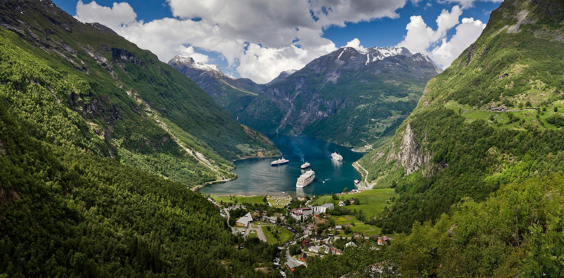
Geirangerfjord, a UNESCO World Heritage Site in western Norway, presents a landscape sculpted by ancient glaciers, where sheer rock faces plunge into profound blue waters. This 15-kilometer-long arm of the larger Storfjord is celebrated for its dramatic contours, marked by towering mountains, flowing waterfalls, and historic mountain farms. The village of Geiranger, situated at the fjord's terminus, acts as a gateway for experiencing this extraordinary natural wonder.
Regarded as one of the most spectacular fjords globally, Geirangerfjord's beauty has earned international recognition, sharing its UNESCO status with the Nærøyfjord as part of the 'West Norwegian Fjords' site. The area imparts a profound sense of scale, with peaks ascending up to 1,700 meters above sea level and the fjord reaching depths of 260 meters. Whether arriving by cruise ship, automobile, or on foot, Geirangerfjord unveils a landscape that feels both immense and deeply connected to its natural and human story.
The narrative of Geirangerfjord commences millions of years ago, during the Pleistocene era. Tectonic forces elevated and tilted western Norway, preparing the ground for successive ice ages. Enormous glaciers then carved out the deep, U-shaped valleys that define the fjord's topography today. As these glaciers receded, their meltwaters filled the valleys, creating the deep, sub-sea-level waters and sheer crystalline cliffs characteristic of the fjord. The resilient granite rock of the surrounding mountains resisted erosion, contributing to the dramatic steepness of the fjord walls.
Human presence in the Geirangerfjord area extends back to the Stone Age, with evidence of continuous habitation through the Bronze and Viking Ages, and into the Middle Ages. By the mid-15th century, a settled community had taken root, constructing its first chapel. Records from 1589 mention an old church, likely a wooden chapel, further indicating a long-established community.
Life along the fjord was often demanding, with farmers in the 17th and 18th centuries cultivating even the most improbable patches of land high on the mountainsides for pasture. These mountain farms, such as Skageflå and Knivsflå, stand as testaments to the resourcefulness and endurance of those who lived in this challenging environment. Many of these farms were eventually abandoned due to the severe conditions and the peril of falling rocks.
The 19th century brought significant transformation, ending Geiranger's extended isolation. In 1858, a scheduled steamship route began calling at Geiranger, providing a regular link to other villages and the coastal town of Ålesund. This improved connectivity allowed for easier trade and the arrival of news from the wider world.
Geiranger achieved international acclaim in July 1890 when German Kaiser Wilhelm II visited with a fleet of royal ships. Captivated by the scenery, the Kaiser returned almost every summer until World War I, providing invaluable exposure and placing Geiranger on the map for Europe's elite. In 1936, the inauguration of the Geiranger-Trollstigen road, with its impressive hairpin turns, further enhanced accessibility for travelers. Today, the Geirangerfjord, alongside the Nærøyfjord, holds UNESCO World Heritage Site status, a designation received in 2005, acknowledging its exceptional natural and cultural value and ensuring its preservation.
The Geirangerfjord offers a wealth of sights and activities, primarily focused on its dramatic natural contours. A boat journey on the fjord is essential to fully appreciate its grandeur and the waterfalls. Options include larger ferry-type vessels, which also transport vehicles between Geiranger and Hellesylt, or smaller, swifter RIB boats that provide a more intimate experience, drawing closer to the cascades.
Three renowned waterfalls plunge into the fjord: the Seven Sisters, recognized for their delicate, ribbon-like appearance; the Suitor, positioned opposite the Seven Sisters; and the Bridal Veil, named for its graceful, flowing form. These are best observed from the water.
For expansive views, several lookouts offer different perspectives. Ørnevegen (the Eagle Road) provides a high vantage point overlooking the fjord. Flydalsjuvet offers a classic view of Geiranger village and the fjord. The Geiranger Skywalk Dalsnibba, at 1,500 meters above sea level, delivers sweeping mountain-studded panoramas over the fjord's end.
Exploring Geiranger village itself is rewarding. It features charming wooden structures, local shops, and cafes. The Norwegian Fjord Centre presents exhibitions and a cinema detailing the formation and story of Norway's fjords. From the village, one can also embark on the Waterfall Walk, a path with 327 steps and viewing platforms that ascend alongside the Storfossen waterfall to the Norwegian Fjord Centre.
Hiking is a favored activity, with trails suitable for various skill levels. A notable walk leads to the abandoned Skageflå mountain farm, situated 250 meters above the fjord, offering views of the Seven Sisters. Other options include the gentle Vesteråsfjellet walk and the more challenging trek to Storsæterfossen waterfall, where it is possible to walk behind the gushing water.
The ideal time to visit Geirangerfjord is during the early summer, in May or June, when the waterfalls are at their most voluminous due to melting snow, and the winding roads are clear of ice. Mid to late summer, from July to August, offers the warmest weather and longest daylight hours, though it is also the busiest period with the highest concentration of cruise ships. September is also a fine choice, with fewer crowds and pleasant weather, though some services may begin to close towards the end of the month.
While winter (November to April) brings cold temperatures and significant snow, it offers a magical landscape and the possibility of witnessing the Northern Lights. However, many scenic roads are closed, and some establishments operate seasonally.
Geiranger is accessible by car, bus, and ferry. The closest airport is Ålesund International Airport (AES), with daily flights from Oslo and Bergen. From Ålesund, Geiranger is about a two-and-a-half-hour drive. Driving offers scenic routes, but be aware that some mountain roads may close in colder months.
Ferries are a favored method to experience the fjord. The Geiranger–Hellesylt ferry is a car ferry that also functions as a sightseeing journey, traversing the length of the fjord. Public buses operate in summer, with routes from Åndalsnes and connections from Ålesund via Hellesylt. Cruise ships frequently call here, especially during peak season.
Accommodation options range from hotels in Geiranger village to camping sites. Many services, including restaurants and hotels, are seasonal, so visiting in summer provides the widest selection. The Geiranger Tourist Office is located at the Visit Geiranger ticket office by the port from May to October, and at the Norwegian Fjord Centre during winter.