Embalse Corriental
Los antiguos mayas de Tikal diseñaron un sofisticado sistema de agua, pero un embalse guardaba un sorprendente secreto sobre sus conocimientos avanzados.
La historia completa se desbloquea en el tour
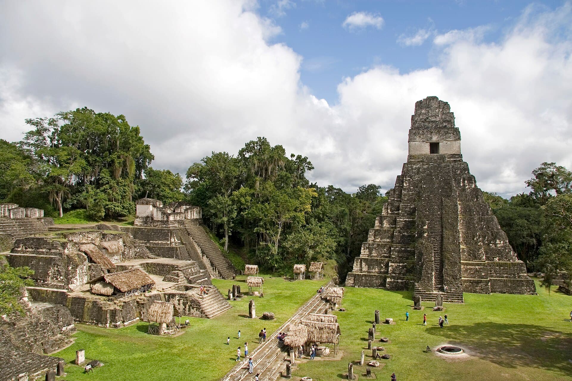 Mundo Maya / CC BY-SA 4.0, via Wikimedia Commons
Tour de audio autoguiado de Tikal — ruta GPS a pie, reproducción offline, narración en 32 idiomas.
“Donde gigantes ancestrales perforan el dosel de la selva y los secretos susurran desde la piedra.”
No las postales. Las historias que ni los locales conocen — al oído, justo donde ocurrieron.
Los antiguos mayas de Tikal diseñaron un sofisticado sistema de agua, pero un embalse guardaba un sorprendente secreto sobre sus conocimientos avanzados.
Este extenso complejo de palacios y patios sirvió como el corazón de la vida real de Tikal, sin embargo, sus secretos enterrados revelan un enfoque inesperado hacia sus muertos.
Esta plaza única, llamada así por su hilera de templos más pequeños, ofrece un contraste tranquilo con las grandes pirámides de Tikal, pero su diseño alberga una rara característica arquitectónica.
Descubre todos los secretos de Tikal
Cada dirección, cada revelación al completo — a tu oído, justo donde ocurrió.
Eliges tus paradas. Caminas. La voz te revela lo que los demás ignoran.


Lume incluye una guía de realidad aumentada. Levanta el móvil y su cámara muestra la calle que tienes delante, con una flecha luminosa sobre la imagen real que siempre apunta a tu próxima parada — sin mapas que descifrar, sin giros equivocados. Como todo en Lume, funciona completamente sin conexión.
Tikal, una antigua ciudad en lo profundo de la selva petenera de Guatemala, se erige como uno de los sitios arqueológicos más grandes y significativos de la civilización maya precolombina. Una vez conocida como Yax Mutal, que significa "Primer Mutul", Tikal fue la capital de un poderoso reino maya que floreció durante siglos. Hoy, es un sitio Patrimonio de la Humanidad por la UNESCO, celebrado tanto por su importancia cultural como por el parque natural circundante, una vasta extensión de bosque tropical, sabanas y humedales.
El sitio abarca miles de estructuras, aunque solo una fracción ha sido excavada, dejando gran parte de la antigua ciudad aún velada por la selva. Templos imponentes, grandes palacios y plazas ceremoniales emergen del denso dosel, ofreciendo un vistazo a una civilización sofisticada que prosperó durante más de mil años. Los visitantes pueden explorar la monumental arquitectura de piedra caliza, caminar por antiguas calzadas y sumergirse en un entorno rebosante de diversa vida silvestre, desde monos aulladores hasta loros coloridos.
La evidencia sugiere que Tikal estuvo habitada desde el año 1000 a.C., con rastros de agricultura que datan de este período. Para el 300 a.C., se había desarrollado en un próspero centro urbano. La línea dinástica de Tikal se estableció tan temprano como el siglo I d.C. y abarcó 800 años, incluyendo al menos 33 gobernantes. Durante el Período Clásico, aproximadamente del 200 al 900 d.C., Tikal alcanzó su apogeo, convirtiéndose en la potencia política, económica y militar de la región mesoamericana.
Los mayas de Tikal fueron maestros ingenieros y arquitectos. Construyeron estructuras monumentales de piedra caliza, incluyendo templos que se elevaban más de 70 metros de altura, extensos palacios reales y numerosas pirámides y edificios residenciales más pequeños. El diseño de la ciudad incorporaba calzadas elevadas, conocidas como sacbeob, que unían varios complejos arquitectónicos y atravesaban tierras bajas pantanosas, facilitando el movimiento y sirviendo como presas. Calzadas notables incluyen las calzadas Maler, Maudslay, Tozzer y Méndez.
Un intrincado sistema de gestión del agua fue crucial para sostener la gran población de Tikal, que en su apogeo pudo haber alcanzado los 90,000 habitantes. La ciudad dependía completamente del agua de lluvia, recolectada y almacenada en una red de diez embalses. Este sofisticado sistema evolucionó durante mil años, con embalses como los del Templo y el Palacio excavados en la roca madre y conectados por un sistema de cascadas de compuertas para regular el flujo de agua. Los mayas también utilizaron barrancos naturales, o arroyos, ensanchándolos para crear estas vitales fuentes de agua.
A pesar de su grandeza, Tikal experimentó un declive hacia finales del siglo IX d.C. y fue en gran parte abandonada a principios del siglo X. Las razones exactas de este colapso siguen siendo objeto de debate entre los historiadores, con teorías que incluyen la sobrepoblación, la sequía y la guerra. Las estructuras monumentales de la ciudad fueron gradualmente reclamadas por la selva.
Aunque el conquistador español Hernán Cortés pasó a pocos kilómetros de las ruinas en 1525, no las mencionó. No fue hasta 1848 que una expedición enviada por el gobierno guatemalteco redescubrió oficialmente el sitio. Las principales excavaciones y esfuerzos de restauración por parte de la Universidad de Pensilvania y el gobierno guatemalteco comenzaron en las décadas de 1950 y 1960, llevando muchas de las estructuras de Tikal a su estado actual. En 1979, el Parque Nacional Tikal fue declarado Patrimonio de la Humanidad por la UNESCO.
Tikal ofrece una combinación cautivadora de arquitectura antigua y selva vibrante. La Gran Plaza forma el corazón de la ciudad, flanqueada por dos estructuras icónicas. El Templo I, también conocido como el Templo del Gran Jaguar, es una pirámide de 47 metros de altura que sirvió como tumba para el Rey Jasaw Chan K'awiil I. Directamente enfrente se encuentra el Templo II, o el Templo de las Máscaras, que los visitantes pueden subir para disfrutar de vistas del Templo I y la plaza.
Para obtener vistas panorámicas del dosel de la selva y otros templos, ascienda al Templo IV, la estructura más alta de Tikal con 65 metros (212 pies). Esta pirámide, también conocida como el Templo de la Serpiente Bicéfala, fue construida en el 741 d.C. para honrar al Rey Yik'in Chan Kawil. El Complejo Mundo Perdido es uno de los complejos ceremoniales más antiguos de Tikal, con una pirámide y tres templos influenciados por el estilo arquitectónico de Teotihuacán. La Acrópolis Central, un complejo de palacios y patios al sur de la Gran Plaza, sirvió como centro administrativo y residencia real. Una exploración más profunda puede llevar a la Plaza de los Siete Templos, caracterizada por una hilera de siete templos más pequeños y un singular juego de pelota triple. En todo el parque, encontrará numerosas estelas y altares, monumentos de piedra tallada que representan retratos reales y textos jeroglíficos, ofreciendo información sobre la historia dinástica de Tikal.
La mejor época para visitar Tikal es durante la estación seca, que va de noviembre a abril. Este período ofrece temperaturas más agradables, menor humedad y mejores condiciones de los senderos. Febrero y marzo son meses particularmente buenos, a menudo con un clima más fresco y seco y menos multitudes. Si bien la temporada de lluvias (de mayo a octubre) trae lluvias por la tarde que pueden hacer que los senderos estén embarrados y aumentar la actividad de insectos, la selva es excepcionalmente verde y las ruinas adquieren una apariencia dramática cuando están mojadas. Se recomiendan las visitas temprano por la mañana y al final de la tarde para una experiencia más tranquila y la oportunidad de presenciar el amanecer o el atardecer.
El Parque Nacional Tikal está ubicado en el Departamento de Petén, al norte de Guatemala, aproximadamente a 500 kilómetros de la Ciudad de Guatemala. La ciudad principal más cercana para alojamiento es Flores, a aproximadamente una hora en coche, aunque el pueblo de El Remate también ofrece opciones más cercanas al Lago Petén Itzá. Algunos lodges están disponibles dentro del propio parque nacional.
Los visitantes deben comprar sus entradas con anticipación en un banco Banrural; la compra directa en la entrada del parque no es posible. El parque está abierto de 6:00 AM a 6:00 PM. Los tours al amanecer o al atardecer requieren una entrada adicional. Explorar todo el parque puede implicar caminar al menos 10 kilómetros, por lo que es esencial llevar calzado cómodo. Prepárese para un entorno de selva tropical, lo que significa humedad e insectos, especialmente durante la temporada de lluvias.
Tikal en coreano, en chino o en hebreo — y 29 idiomas más, cada parada narrada por una voz nativa. La mayor variedad de idiomas de cualquier audioguía autoguiada.
Disponible en: