The Sundial Bridge
This remarkable glass bridge serves as more than a way for pedestrians to cross or a striking architectural feature.
Full story unlocks in the tour
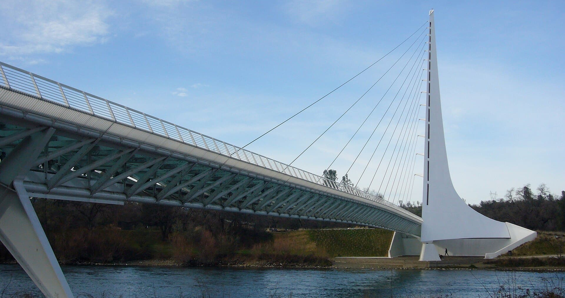 Chad K / CC BY 2.0, via Wikimedia Commons
Self-guided audio walking tour of Redding — GPS route, offline playback, story-driven narration in 32 languages.
“Where pathways converge with serenity, and ingenuity stretches across the river.”
Not the postcards. The stories even locals don't know — whispered in your ear, right where they happened.
This remarkable glass bridge serves as more than a way for pedestrians to cross or a striking architectural feature.
Beneath the clear waters of this beloved recreation area lies a fragment of Gold Rush history.
This monumental structure, crucial to California's water infrastructure, was finished through a remarkable engineering feat during wartime.
Discover every secret of Redding
Every address, every reveal in full — in your ear, right where it happened.
You pick your stops. You walk. The voice reveals what the others miss.


Your self-guided audio tour of Redding is ready — pick your landmarks, choose your language, and start the moment you arrive.
BuyLume has a built-in augmented-reality guide. Hold your phone up and its camera shows the street ahead of you, with a glowing arrow laid over the real view that always points to your next stop — no map to puzzle over, no wrong turns. Like everything in Lume, it works fully offline.
Redding, California, is a city that thrives on its connection to the natural world, earning designations such as the "Trail Capital of California" and the "Unofficial Capital of Kayaking." Positioned in Northern California, it acts as a central point for the Shasta Cascade region, with the Sacramento River flowing directly through its core. This city presents a distinctive blend of natural splendor and urban conveniences, offering residents and visitors abundant opportunities for recreation alongside an expanding economy and a robust sense of community.
Enjoying over 300 days of sunshine each year, Redding stands as one of the sunniest cities in the U.S., making it an ideal destination for outdoor pursuits throughout the year. The city functions as an entry point to three significant natural landmarks: Mount Shasta, Shasta Lake, and Shasta Dam. Its varied terrain, from picturesque rivers and expansive lakes to volcanic landscapes and numerous waterfalls, invites exploration and adventure.
Prior to becoming Redding, the area was known as Poverty Flats during the California Gold Rush, a name reflecting the limited gold deposits discovered there. However, its strategic position at the northern edge of the Sacramento Valley would soon prove valuable for another burgeoning industry: the railroad. In 1868, Benjamin B. Redding, a land agent for the Central Pacific Railroad, acquired land in Poverty Flats, leading to the establishment of a train station and a town named in his honor in 1872.
The naming of Redding was not without its brief contention. In 1874, local legislators attempted to alter the town's name to Reading, in homage to Pierson B. Reading, an early settler and landowner in the region. However, by 1880, the name was officially restored to Redding. The early 20th century saw economic growth fueled by mineral extraction, particularly copper and iron. This industry eventually declined, causing an economic downturn and population decrease by 1920.
The city experienced a substantial recovery in the 1930s with the initiation of the Shasta Dam's construction. Constructed between 1938 and 1945, this massive concrete gravity dam on the Sacramento River not only provided flood control and power but also nearly doubled Redding's population and stimulated regional development. The dam played a crucial role during World War II, supplying electricity to California factories. Following the war, the lumber industry saw a decline in the 1970s, intensified by environmental preservation efforts in the early 1990s. Nevertheless, a retail and housing expansion in the late 1980s and mid-1990s helped the economy recover. The Market Street Redevelopment Project, commenced in 1968, further aimed to revitalize the downtown area, leading to the development of the Midtown Mall in the 1970s. Today, Redding maintains a diverse economy, with healthcare, retail trade, and accommodation and food services being major employers.
The Sundial Bridge at Turtle Bay is a pedestrian crossing over the Sacramento River, designed by Santiago Calatrava. Completed in 2004, its distinctive pylon functions as a gnomon for a large sundial. The bridge's deck is crafted from translucent glass that glows aquamarine after dark. It connects the two campuses of Turtle Bay Exploration Park and offers access to Redding's extensive network of trails.
Just a brief drive from Redding, Shasta Dam stands as a monumental concrete gravity dam, creating the largest reservoir in California, providing expansive views of Shasta Lake and Mount Shasta. Complimentary guided tours are available, including an elevator descent to the dam's base and visits to its interior galleries and powerhouse.
Whiskeytown National Recreation Area, situated west of Redding, features the clear waters of Whiskeytown Lake. This area is popular for swimming, boating, kayaking, and angling, with ranger-led kayak excursions available. Visitors can also explore waterfalls like Whiskeytown Falls and Boulder Creek Falls, or delve into Gold Rush history at the Tower House Historic District.
For those seeking culinary experiences, Redding presents a varied dining landscape, from American classics at Jack's Bar and Grill, the city's oldest continuously operating restaurant, to California-inspired cuisine at Mosaic Restaurant near the Sundial Bridge. The city also offers a lively craft beer scene with several breweries and a dynamic food truck park, The Park, providing a range of options and entertainment.
The most favorable times to visit Redding are during the spring (April to May) and autumn (October). These months provide pleasant temperatures, low humidity, and ample sunshine, ideal for outdoor pursuits. Spring brings warming weather and spectacular waterfalls, while autumn displays vivid foliage and remains agreeable for swimming and trail exploration. Summers in Redding are typically hot and arid, with July often experiencing average high temperatures around 100°F (38°C), making mornings the optimal time for outdoor activities. Winters are mild and damp, with occasional light snowfall, particularly from November to early March.
Redding Regional Airport (RDD) provides commercial airline passenger service with direct flights to major centers like San Francisco (SFO), Los Angeles (LAX), and Seattle (SEA). Once in Redding, the downtown area is largely navigable on foot. For exploring further afield, options include rental cars, taxis, and rideshare services such as Uber and Lyft. The Redding Area Bus Authority (RABA) offers public transportation throughout Shasta County with fixed routes and a microtransit service called RABA Runabout, providing door-to-door service within designated zones. A bikeshare program is also accessible for traversing the city and its trails.
Redding's cost of living is generally more approachable than the California average, particularly for housing. The median home value in Redding was approximately $382,300 in 2024, considerably lower than the state's average. The city's economy is stable, with major employers in healthcare, retail, and hospitality.
Redding in Korean, in Chinese or in Hebrew — and 29 more languages, every stop narrated by a native voice. The widest language range of any self-guided audio tour.
Available in: